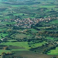
Albagiara
Albagiara
ultimo aggiornamento: 15 maggio 2015
Sindaco: Maurizio Malloci (dal 16/05/2011)
Abitanti: 283 (statistiche ISTAT 2011)
Posizione: 39°47'13" N - 08°51'52" E
Altitudine s.l.m.: 215 m
Superfice: 9,00 kmq
Codice Istat: 095003
Codice Catastale: A126
Cap: 09090
Patrono: San Sebastiano (20 Gennaio)

The municipality of Albagiara, known too with its ancient name of “Ollastra” , is located at the foot of the north versant of the Giara Tableland. Both toponyms are highly evocative; they highlight the strong link between the village and its territory: “Albagiara” means “the sun rises from the Giara”, while “Ollastra” means “olive village” (the olive is a symbol of peace).
Albagiara stretches over a flat country strip, holding much archaeological evidence, such as the nuraghs of Bingias, Furisinu, Lea and St. Lussorio. The last one is surrounded by an out-and-out nuraghic village. There are also the remains of the Roman age: excavations have dug up various tombs with their grave goods, ancient walls and pottery.
The present-day historic centre has medieval origin and shows typical “a corte” (with a court) houses. Among the most ancient monuments there are St. Peter’s Church (built in the 16th century, in late Gothic forms) and St. Sebastian’s parish church (with seventeenth-century origins).
From the olive and almond groves surrounding Albagiara municipality it is possible to obtain top quality oils and almonds, utilized for the confection of traditional sweets like “amaretti” (macaroons), “gattou” and “guefus”.
Municipality official website: www.comune.albagiara.or.it


