Sini
Sini
ultimo aggiornamento: 16 maggio 2015
Sindaco: Biagino Atzori (dal 31/05/2010)
Abitanti: (statistiche ISTAT 2011)
Posizione: 39°45'18" N - 08°54'25" E
Altitudine s.l.m.: 255 m
Superfice: 8,70 kmq
Codice Istat: 095060
Codice Catastale: I749
Cap: 09090
Patrono: Santa Chiara (12 Agosto)

Sini is situated at the foot of the Giara di Gesturi tableland, among green hills of Marmilla and its almonds, vineyards, century-old olive trees and fields with cereal-growing.
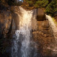
When the river is in spate, the splendid municipal park of Cracchera is animated by “Su Strumpu” waterfall, that rises among splendid century-old oaks. The surrounding territory is dotted with archaeological evidence of ancient epoch, such as the following nuraghs: Gorropis, Perdosu, Sa Domu Bianca, Santu Giorgi, Scal’e Brebeis.
In the month of April Sini is animated by St. George’s feast and the Festival of "Su Pani e Saba", dedicated to the savoury sweet of Sardinian tradition.
Municipality web site: www.comune.sini.or.it


