Pauli Arbarei
Pauli Arbarei
ultimo aggiornamento: 16 maggio 2015
Sindaco: Egidio Cadau (dal 16/05/2011)
Abitanti: 648 (statistiche ISTAT 2011)
Posizione: 39°39'46" N - 08°55'23" E
Altitudine s.l.m.: 136 m
Superfice: 15,10 kmq
Codice Istat: 92046
Codice Catastale: G382
Cap: 09020
Patrono: San Vincenzo (22 Gennaio)

Pauli Arbarei is situated on a plain, next to a vast marsh. Many traces of nuraghic epoch settlements are still visitable in Is Lapidas locality and nearby the village, where there are the Seneri nuragh and Corti Boccas settlement. There are also prehistoric evidences, in particular of the Bronze Age, including nine nuraghs with one tower and a complex one.
In the documents going back to the Middle Age, the village is mentioned with various toponyms: Pauli Arbarei, Arbaraghesa or Pauli Sitzamus, deriving by the belonging “giudicato” (Arborea).
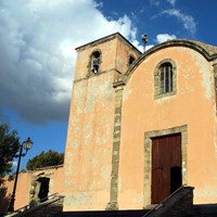
In the streets of the historic centre it is possible to recognize Low Marmilla typological constants, as the houses with sa lolla” and their high stone walls. The historic centre includes the Churches of St. Vincent Deacon, St. Isidoro and St. Augustine, where in the end of August this Saint is celebrated.
In the core of the village, realized on the premises of the former Monte Granatico (Bank of Grain), it is possible to visit the Museum of the Woman, dedicated to Sardinian female mythology fanciful personages. The exhibition includes visual and sonorous installations, which reproduce an out-and-out labyrinthine path, which takes inspiration from ancestral myths linked to the female figure in Sardinia.
Municipality web site: www.comune.pauliarbarei.vs.it


