Siris
Siris
ultimo aggiornamento: 16 maggio 2015
Sindaco: Marco Floris (dal 29/05/2006)
Abitanti: 231 (statistiche ISTAT 2011)
Posizione: 39°42'51" N - 08°46'28" E
Altitudine s.l.m.: 161 m
Superfice: 6,00 kmq
Codice Istat: 095061
Codice Catastale: I757
Cap: 09090
Patrono: San Sebastiano (19 Gennaio)

The municipality of Sinis is situated on Mount Arci’s southern scopes; it is surrounded by woods of holm-oaks, durmasts and corks, alternating with splendid Mediterranean scrub typical of Sardinian landscapes, with colours and flavours of myrtle, lentisks and strawberry trees.
Mount Arci’s area (including Siris) gives charming settings and embraces a complex of spectacular trachyte crags (Su Colombariu), that hold numerous caves, such as the one of Rio Bingias (river), which opens onto its source, particularly famed for the curative properties of its fresh water.
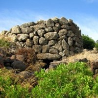
The territorial history of Siris is very ancient, as it is proved by the remains of domus de janas, typical sepulchres of Sardinian Neolithic, and numerous nuraghs such as the Inus one, which towers the village from the top of the Giara. Also the Roman period left considerable traces, as tombs, pottery and coins, excavated nearby Porcilis nuragh. Along the faces of Siris hills some tunnels (still partially unexplored) were discovered. The legend has it that from these tunnels there comes a sweet nightingale song able to attract visitors like a siren.
Walking along the hamlet narrow and tortuous alleys, it is still possible to admire Campidano traditional ancient houses, with their big stone portals.
Nearby the historic centre there is St. Vincent’s church, recently recovered and skillfully restored to its original splendour. Tradition says that some meters from the building there is a century-old olive tree, whose roots keep the Saint’s treasury.
Municipality web site: www.comune.siris.or.it


