Barumini
Barumini
ultimo aggiornamento: 15 maggio 2015
Sindaco: Emanuele Lilliu dal maggio 2010
Abitanti: 1.339 (statistiche ISTAT 2011)
Posizione: 39°42'13" N - 09°00'8" E
Altitudine s.l.m.: 202 mt
Superfice: 26,60 kmq
Codice Istat: 092006
Codice Catastale: A681
Cap: 09021
Patrono: San Sebastiano (20 Gennaio)

The municipality of Barumini is situated at the foot of the Giara of Gesturi. Southward, it is surrounded by Las Plassas breathtaking hill.
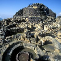
The municipality territory is characterized by the presence of twenty-seven nuraghs, in basaltic stone. The group of Su Nuraxi, datable to the 2nd millennium B.C., represents one of the greatest expressions of Sardinian megalithic civilization. Since 1997 it has been recognized and protected by UNESCO as Heritage of Humanity.
Barumini counts in its territory the presence of Nuraxi e' Cresia, a very ancient nuragh located nearby the parish church. On that church in the end of the sixteenth century there was built Marquesses Zapata’s baronial palace. Since 2006 the Spanish residence is the seat of the so-called “Casa Zapata” Museum Centre, that is organized in three areas: archaeological, historic- archival and ethnographic sections.
Municipality official website: www.comunebarumini.it


